|
Web-based mapping is an activity of growing importance in many countries around the world, especially in places where base map data is often scarce and out of date. Governments are collecting more and more data, including geospatial data, and are beginning to understand the social and economic benefits of sharing the data. As part of the World Bank-DFID partnership to support Open Data in the Caribbean, I was invited by a fellow GIS consultant to help him conduct one-day open mapping workshops in St. Lucia and Jamaica. How could I say no? Within a week we had made arrangements and managed to organize the TeachOSM sessions - let's do this! St. LuciaThe first session was held in Castries, the capitol of St. Lucia. The group was one of the sharpest and best humored that I have encountered to date. I truly enjoyed the day and was a bit disappointed by my low energy levels - I wanted to give them more. Each workshop began with a one-hour plenary session that introduced the growing ecosystem of open source mapping, including OSM, QGIS, Field Papers, and Mapillary, and was targeted to senior executives and administrators. News outlets were present, and I began the morning be elegantly knocking over the too-tall microphone right in front of the TV camera - excellent.... ! The plenary was followed by an invitation-only six-hour training on using OpenStreetMap and QGIS. The training covered basic editing skills, digitizing, an overview of aerial image interpretation in OSM, tagging protocol, and an overview of ancillary technologies important to the open map data workflow (e.g. Mapillary, FieldPapers, Overpass Turbo, etc.). There was a live demonstration and step-by-step instruction in using OSM and Open Data in QGIS. The end of the day was spent covering meta-level organization of mapping events and community management. It was a success, which made the ice-cold Piton beer at the end of the day taste even better! We only had a few days in St. Lucia and wanted to see a bit of the island, so opted to leave a bit early for the airport and take the long, winding, route through the Pitons back to the south. I was car sick approximately 10 minutes into the 2 hour drive down the west coast to UVF. Our van was moving at what felt like record speed along roads that belong on Top Gear, but in reality when I peered up at the dash we were going a startling 40 km/hr. The west coast of the island is stunning in the dry season, and I can only imagine what a difference lush, green vegetation might make in the views. We passed through 3 towns, stood atop two breathtaking vistas, and I only just avoided losing my french toast to the Pitons. Our driver, Marvin, seemed immune by the ride, smiling all the way listening to Disney ballads, 80s classics, and rap all the way. I found myself singing along to the likes of Lady in Red and Alladin's Magic Carpet Ride. I also learned that St Lucians are very fond of country music, and that on Friday and Saturday nights young women will be found in droves out at line dances and country music venues. Sad to miss that, along with the Friday Fish Fiesta in Gros Islet! St. Lucia, I think I'll be back! Kingston, JamaicaOur arrival in Kingston coincided with Caribbean Fashion Week, so there were no hotels to be found in our price range. After scrolling through an abundance of places on AirBNB, I booked 2 rooms at Moon Hill Jamaica - home of the author of the Moon Jamaica travel guide. A driver met us at the airport and whisked us away to the mansion on the hill. We arrived on Saturday, so we had time to enjoy the property and prepare for our Monday session. The guard dogs were a bit unnerving and I hope you like reggae on vinyl - it will be piped into the sound system that is audible throughout the house... bonus! The proprietor was welcoming and helpful, and the food was so good we didn't leave until Monday morning for the training! The house is gorgeous, and I highly recommend this place. The participants in Jamaica were just as enthusiastic as those in St. Lucia. One moment will always make me laugh though - when choosing OSM user names, one participant cried out - "but Rastafarian is taken, what do I do?!" Turns out one of our St. Lucia participants had chosen the name the previous week. The participants also added a new religion to OSM, as Rastafarianism was not yet included in the OSM database. It goes to show there is always something new to map! In Jamaica we were interviewed by Nationwide News Network and NewsTalk93 FM, and the event was covered by the Daily Observer newspaper. We were excited by the press coverage, and the opportunity to train approximately 70 people in the two countries. There was a diverse industry representation among participants, with many having previous GIS experience. I was motivated and inspired by the enthusiasm in both countries, and the experience helped me realize that the potential for TeachOSM is high. These workshops represent first steps to realize countries based on open geo data. Technology alone will not provide the organizational structure for newly minted mappers; to sustain an open source project requires a community of active mappers, and I hope to see continued investments in open map data for the citizens of Jamaica and St. Lucia, and throughout the Caribbean. I look forward to growing TeachOSM and spreading the use of OpenStreetMap globally! A blog post was also written for HOT that can be found here: https://hotosm.org/updates/2015-08-31_open_data_open_mapping_teachosm_in_the_caribbean
0 Comments
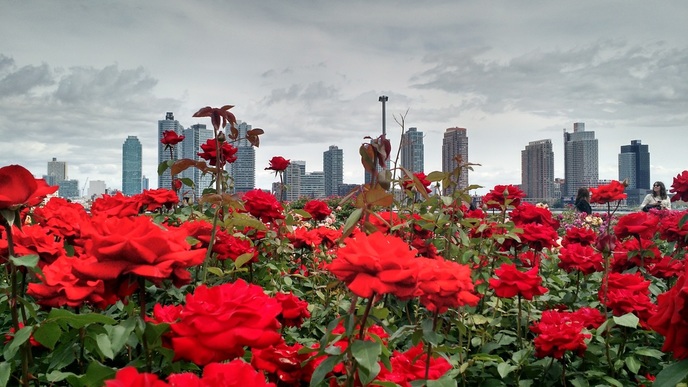 The $12, two and a half hour Bolt bus ride from Philadelphia was quiet, warm, and a bit nausea-inducing – but we managed to make it to NYC on a Friday during the summer with ease. I hopped off the bus and made my way through the hustle and bustle of the city streets into the depths of the subway. Having not been in New York for some time, I had forgotten about the absence of escalators throughout much of the subway system. Feeling a bit like a pack mule, my three bags and I made it down the long stairwells and through the throngs of fast-moving, impatient New Yorkers. The State of the Map US conference was held at the United Nations headquarters – an impressive compound overlooking the East River. SoTM has been held each year since 2007, and is the annual conference of OpenStreetMap. This was my first SOTM in the US, and the sheer number of people was overwhelming. The conference brought together 850+ OpenStreetMappers, which made navigation a bit difficult at times, but there was no shortage of networking opportunities and there was a gorgeous rose garden on the grounds for those times when one might need peace and quiet. It was a great turnout, especially when you think that SOTM had 65 people in attendance in 2010. Much of Saturday was spent networking and meeting new people, and while not chatting in the lobby there were 3 tracks and many sessions to choose from. Saturday night the group took buses to Studio Square in Astoria, a large restaurant with a beer garden, a plethora of taps, and the chance to relax and talk even more about maps. Sunday brought more sessions showcasing the diverse uses of OSM, including Missing Maps, Peace Corps and OSM, OpenMapKit, and Getting OSM Schools Through Geobadges. Topics were thoughtful and inspiring, and they reinforced my belief that OpenStreetMap will grow and continue to transform lives through education, disaster relief, navigation, community development - really, the applications are endless! Sunday evening a large group headed to the Staten Island Ferry to cruise past the Statue of Liberty – it was quite a feat to get that many people herded onto subways and into the same ferry! Most of the group did a u-turn as soon as we arrived at Staten Island, but 3 of us stayed behind and caught a later ferry, which allowed us to see the lights come on in the city and float past Lady Liberty ensconced in her evening glow. A fitting finale to the official conference. At the last minute a few colleagues were unable to make the conference, so I stayed Monday to help facilitate a TeachOSM session. We had a decent turnout, and despite having half of a voice the session was a success. The idea for TeachOSM was born at the 2014 SOTM US, and it was inspiring to see this first educational session come to fruition. The TeachOSM mission is to promote and advocate the use of the OpenStreetMap platform to teach the fundamental concepts of geography and mapping - apropos! That night was the closing session with GeoNYC at Mapzen off of Broadway, complete with pizza, beer, and more chances for noisy networking. Around 8:30 I decided to call it a night and was on my way to the subway, when a few congas, a keyboard and a xylophone in the window of a neighboring sushi restaurant caught my eye - of course I took a closer look! A nice guy out front informed me that it was Toshi's Soul Night, and the “best soul night in the city!” It was free, and his enthusiasm lured me to stick around for a few tunes. Well, despite my impending 9am flight, I couldn't seem to pull myself away. The music was fantastic, the crowd was engaged, and I had also sat down next to a lovely young woman who had performed the first set and was happy to fill me in on all kinds of fun details about the music scene and idiosyncrasies of a life in NYC. By the second set I found myself on the dance floor, and in the end my new friend and I shared an Uber to the Upper West Side, making promises to meet up again soon; a sweet ending to a busy and exciting weekend in the Big Apple! That 7am cab to JFK felt even earlier, but my thoughtful cousin had packed me snacks for the plane, check in was painless and I had no complaints - I was headed to St. Lucia for my first major TeachOSM project – this time for the World Bank! A big thank you to the OSM Foundation for organizing such a great gathering. I am already looking forward to the next one! |
ABOUTCombining a passion for travel, the desire to make a difference & a love of maps, MaggieMaps was born. PRESS
Unless otherwise noted, all prose, poetry, maps and photography posted on this blog are Copyright 2013 Maggie Maps
Archives
March 2020
Categories
All
Blogs I like |
 RSS Feed