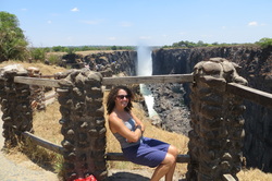
 Victoria Falls is a place I've wanted to see for a long time. I love water, and it is the largest curtain of water in the world (not the highest or widest waterfall, but it has the worlds largest sheet of falling water). Pictures and documentaries of it are all incredibly powerful. But those artists don't show it to you in the dry season do they? Well, it is the dry season and Vic Falls is a trickle. What luck! The cliff and rock formations are incredible though, and this time of year the water creates small pools on the cliff's edge. Devil's Pool was a bit pricey, so we went off to find our own cliff side splash pool. Moments before diving into the largest one, a park ranger arrived to kick out the brave and fearless crew. After we all moaned and complained, he gave us 10 minutes to swim. Back in we go! At over 100 degrees, we were all thankful. I'd love to see the Falls in full flow, but its amazing to be able to climb to the edge and peer down that incredible cliff face! After that adrenaline rush, there is also a huge Curio Market where you can pick up all the wooden hippos, elephants, and masks your heart desires. Don't leave for home without your life-size wooden giraffe! The next day, the Aussies and I took advantage of a unique dry season opportunity – whitewater rafting the Zambezi! The River was in full force, with up to Class 6 rapids. We took the half day option with Buntu, and paddled 10 gorgeous and exhilarating rapids. We hopped out of the raft for the Class 6 rapid, which resembled certain death. Even the kayakers avoided it! After a morning on the river, we have to take our gear and hike out of the canyon... It's a brutal and dangerous climb, complete with makeshift ladders along some of the cliff faces. It's straight up and at times I'm not sure why I didn't do the full day rafting to take the cable car up! Thankfully, water is waiting at the top, and so is a great view of the river and canyon below. Gorgeous and well worth it. Now, let's go find out what's happening in Botswana!
0 Comments
Leave a Reply. |
ABOUTCombining a passion for travel, the desire to make a difference & a love of maps, MaggieMaps was born. PRESS
Unless otherwise noted, all prose, poetry, maps and photography posted on this blog are Copyright 2013 Maggie Maps
Archives
March 2020
Categories
All
Blogs I like |
 RSS Feed