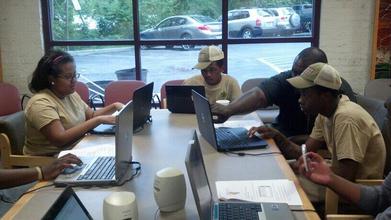
 Getting into the QGIS labs! Getting into the QGIS labs! Last July, I had the honor of introducing 12 high school students in Parks and People's Branches program to geospatial technology. The program went well, the students each made maps after just 1 week, and I truly enjoyed working with some of Baltimore's youth. In May, I learned that Parks and People wanted Boomerang back for a second summer and this became a great incentive to return to the US. BRANCHES had grown, so I had 15 students (4 teams) and two weeks to get them thinking spatially. Having smaller teams allowed for personalized instruction and a great student/teacher ratio. Spatial thinking, the way we navigate the world and manipulate the space around us, is crucial to problem solving. My goal was to impart a basic understanding of data collection and Quantum GIS - chosen in this case for its low barrier to entry and compatibility with the Garmin units on hand at Parks and People. Open source software also allows the students to use it on their own, for free, after our training. End goal? Each student would finish a map, with data they collected, by the final day... and remember what GIS and GPS stood for at their presentations! Last year the 12 students worked together to map the Star Spangled Banner Trail, but this year they decided to develop unique projects. Each team received instruction in QGIS, collecting data with a Garmin, and navigating to Open Data repositories on the net. The next step was to go into the field and collect some of their own data! The first group ventured into Hampden to collect data along the Avenue, with a hike along the Gwynns Falls on the way. Each students was armed with a Garmin GPS, a notebook, and a pen to record attribute information about their waypoints. They mapped shops, amenities, points along the trail, and anything that piqued their interest. After data collection, we went back to the classroom and they learned how to transfer waypoints, add additional data layers, and compose a printed map. Symbology was a favorite skill to practice, and the color combinations were creative & eye-popping! The students shocked me with their attention to detail and spatial awareness - they were much better at direction than some of my colleagues! The second group was interested in mapping the trees they had been pruning in East Baltimore, along Fayette Street. We headed out into Baltimore summer and the students mapped trees they had pruned, trees that needed pruning, and empty tree wells. Back in the classroom, they were able to see all of the progress they had made along Fayette, and where they could focus future efforts. The third group had been building bioswales in West Baltimore all year, and were interested in mapping these & vacant lots. It was a hectic day spent jumping in and out of the work trucks, pulling some weeds in the bioswales, and still managing to get back to the classroom to create the final maps. Luckily, I had these same students last year and they remembered some of the tricks of the trade. Dream team! My final team had many ideas and too little time. They wanted to map all kinds of things about their neighborhoods, and I hope to have more time to work with them next year. We decided on mapping vacant buildings in Reservoir Hill near the Whitelock Community Farm where they had worked all summer. This was quite a feat, and the students were also able to map their homes and some additional points of interest like the neighborhood candy store. It was another successful year with BRANCHES. Many students wish to continue to map their neighborhoods, and have already begun to think about projects for next summer. Each group presented their final maps at the graduation, and one group even explained to the audience what GIS and GPS meant - I was beyond thrilled! Next year I hope to continue building on QGIS, and bring some coding and web mapping into the curriculum. Boomerang's engaging, STEM-focused programs immerse students in spatial technologies with hands-on, project based instruction. Due to a lack of funding we still rely on partner organizations to provide computers and GPS units, which results in a few technical hurdles and plenty of troubleshooting. But Boomerang is seeking funding, and hopes to be able to provide students with great tools in the future! Hope to see you next year BRANCHES!
2 Comments
|
ABOUTCombining a passion for travel, the desire to make a difference & a love of maps, MaggieMaps was born. PRESSUnless otherwise noted, all prose, poetry, maps and photography posted on this blog are Copyright 2013 Maggie Maps
Archives
March 2020
Categories
All
Blogs I like |


 RSS Feed