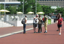
 "We're going to do what?!" Day 1 of a 5 day class .... are we going to make it? Will everyone print a map by Friday? Do I know what I'm getting into? Inhale. Exhale. We got this.... So began last week, when I had the opportunity to teach 12 high school students in Parks and People's Branches program how to collect data and make maps. Branches is a 6 week program, and Parks and People decided to try something new - a pretty excellent decision. My goal was to impart a basic understanding of data collection and Quantum GIS - an open source GIS software that was chosen so that the students could continue to use it on their own, for free. I hoped each student could print a map by day 5... Here is what we did...! Day 1 was a hands on Garmin lesson out in Druid Hill Park. They found out what GIS means, watched a few videos of some cool mapping projects, and did an intro lesson to QGIS. Not bad. Day 2, everyone came back for more, and we ventured down to the Star Spangled Banner Trail in the Inner Harbor for a scavenger hunt and data collection. I went with a group that had to find the Sondheim Fountain - bonus in the heat! ('found' it a few times!) After lunch our team walked around and recorded trees, trash cans, and retail options, and started learning about attributes. My two wonderful assistants joined the other groups so each team had hands on instruction with the GPS. 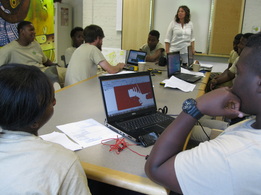 Day 3 - back in the classroom to map the data we collected. Pretty cool to see everyone get excited to see where they were and add some layers to the map. Symbology was also a favorite skill to practice, and the color combinations were eye-poppin. The students shocked me with their attention to detail and spatial awareness - they were much better at direction than some of my colleagues! Day 4 - back out in the heat once more to collect even more data about the Star Spangled Banner Trail. Teams hit Fort McHenry, Latrobe Park, Riverside Park, and Patterson Park. By the end of the day we had information about park amenities, restaurants and retail along the trails - even some data about the smelliest allies in Sobo and all points where a certain member complained about the heat :) Students are pretty creative! 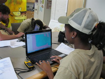 Day 5 was spent making the final maps. Each team ended up with at least one map of their work, and I combined them to show how much they had accomplished in a few short days - More than 150 points and a large chunk of the SSB Trail! It was a fun experience and one that I hope to repeat. I found a new love in teaching, and realized again how great high school students can be. Many wish to continue to map their neighborhoods - pretty great. Who knows - maybe one student will be inspired and end up developing the next best 'geo-tool'. But in the very least, we had a great time, walked away with a better understand of our City and its parks, and put a few new friends on the map.
0 Comments
Leave a Reply. |
ABOUTCombining a passion for travel, the desire to make a difference & a love of maps, MaggieMaps was born. PRESS
Unless otherwise noted, all prose, poetry, maps and photography posted on this blog are Copyright 2013 Maggie Maps
Archives
March 2020
Categories
All
Blogs I like |
 RSS Feed