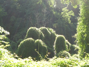
 Vines have killed these trees and are hungry for more... Vines have killed these trees and are hungry for more... Back in May, I got a phone call that encouraged me to found Boom Geo.... it went a bit like this: "Hi Maggie! Friends of Leakin Park is applying for a Hack the Parks grant to make a map of the invasive vines in Leakin Park. I remember that you were starting a mapping company - would you be interested in being a part of this effort?" I pause, just briefly (don't want to sound too desperate) before saying, yes, of course, I'd love to! Let's face it - I had no income, hadn't yet filed my LLC papers, and was so busy "getting things done" I hadn't looked up. Yes, of course I'll help! So we wrote the grant & crossed our fingers. I was even motivated to write a second proposal for Baltimore Tree Map. 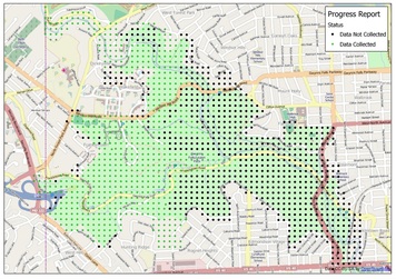 The grid system we used to collect data. Half-way point. The grid system we used to collect data. Half-way point. Six weeks later, MOIT & gb.tc announced the winners - Friends of Leakin Park & Baltimore Tree Map were both among the chosen 7! Awesome. Let's celebrate and take some time to assess: Leakin Park is a 1,200 acre park and I was going to be collecting data for every acre.... When I signed up for the job, it did sound like a huge area to cover, but really, I had no comparisons. Summer just got busy... Now, at first I thought this sounded like a wonderful way to spend my day - walk through a park with a smart phone and rate the invasives? Fresh air, birds singing, great exercise - yes! Goodbye desk! Carpal tunnel - look out! I was happy to accept the challenge and get outside for a change. But isn't the grass is always greener? There are also thickets, holes, mosquitoes, mud slides, downed trees, falling trees, ticks, trash, thorny bushes, and spider webs. Lots and lots of spider webs. And acres of invasive vines. It is sad to see such a beautiful forest being consumed by English Ivy - & it's happening at an alarming rate. 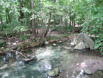 Relatively healthy forest with no sign of vines on the trees. Relatively healthy forest with no sign of vines on the trees. Data collection is the first step in a larger Park Plan, and will also help to increase awareness of the problem. The Friends of Leakin Park have their work cut out for them, but this map will allow them to focus efforts and allocate vine-removal resources a bit more efficiently. Knowing our efforts will help save the forest makes dodging spider webs bearable, and will motivate us to map the final 750 acres. Leakin Park is one of the places you can find true solitude in Baltimore. The forest is full of pleasant surprises, and reminds me to open my eyes to my surroundings, and breathe. I have a feeling mapping that last acre will be bittersweet.
2 Comments
MaggieMaps
9/3/2013 01:07:18 pm
There are still quite a few acres to map out there. Once that is completed, there will be hundreds of acres of invasives to go after! Leave a Reply. |
ABOUTCombining a passion for travel, the desire to make a difference & a love of maps, MaggieMaps was born. PRESS
Unless otherwise noted, all prose, poetry, maps and photography posted on this blog are Copyright 2013 Maggie Maps
Archives
March 2020
Categories
All
Blogs I like |
 RSS Feed