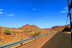
 On the road to Fish River Canyon, Namibia On the road to Fish River Canyon, Namibia After a gorgeous drive we reached Fish River Canyon. The tents went up quickly so we could hop in the car to catch sunset over the canyons. Spectacular. The next time I'd love to stay a few days to hike the area. The campsite was quiet and peaceful, and I awoke to the chatter of birds and monkeys. After a hearty South African breakfast, a short but lovely drive around the canyons led us to the Ai Ais Hot Springs. Ai-Ais means 'burning water' in the local Nama language and refers to the sulfurous thermal hot water springs found at the base of the mountain peaks at the southern end of Fish River Canyon. The water is fed into a large outdoor swimming pool and smaller pools within a resort, and is rich in sulphur, chloride, fluoride and said to be good for anyone suffering from rheumatism. Well, when we arrive the is pool empty - they just happen to be doing some cleaning. We set up camp anyway, and take a look inside. It feels very much like a resort, but there are a few pools both hot and cold and they are delightful. After a dip, I arrive at the camp site for a big Sunday lunch. Turns out the South African has been busy! After our meal the 5 of us go for a sunset hike in the Fish River along the dry sand bed. We see baboons, a few small fish, bats, and birds. A nice way to end the day. By the next morning the water in the giant pool is mid-calf so in we go. While it is not the natural hot springs I had imagined, the water is very warm and feels revitalizing and healthful. Now – back on the road – another 665 km to Kuruman!
0 Comments
Leave a Reply. |
ABOUTCombining a passion for travel, the desire to make a difference & a love of maps, MaggieMaps was born. PRESS
Unless otherwise noted, all prose, poetry, maps and photography posted on this blog are Copyright 2013 Maggie Maps
Archives
March 2020
Categories
All
Blogs I like |
 RSS Feed